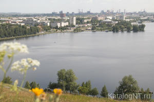


It is located almost at the 60th meridian east and shifted to 10 kilometers to the south of the 58th parallel of north latitude at an altitude of 200 meters above sea level. At 25 kilometers to the west of the city on the Main Ural ridge runs geographical border between Europe and Asia. "Neighborhoods in Nizhny Tagil, - said the singer Urals DN Mamin-Siberian - are among the most beautiful in the whole Middle Urals city ... big picture "is spread in the river Tagil Tagil valley on the banks of the pond, then climbing on one, then on another hill, and in the center of Fox Mountain - its main attraction.
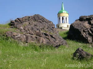
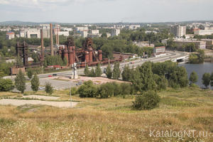
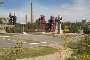
The relief of the city steeply sloping and hilly. Lower parts of the city, located in the valley of the river Tagil have absolute marks within the city of 184-186 meters. Buildings held in the territory of the center with marks 210-214 meters. The highest point - Mount Ptahina (located at the foot of her Demidov house). With Fox Mountain Tagil surface of the pond, residential areas, wide avenues, beautiful waterfront - at a glance. They were factory buildings, arrows, pipes, giant steps, ledges mining, and on the horizon - blue-blue gave the Ural taiga. To the east of the city stretch meridian stripe low hills with elevations of 250-350 meters: Fir, oscular, Sorokin, Sidneva, horst, Guriev mountains. In the north the mountains are clearly visible WALKING - a string of peaks along the right bank of the river Tagil, ending with the mighty 100-meter cliff Bear Rock. West frozen bluish-green waves stretch mountain ranges: the first - the mountain peaks of the mountains of debt, bare rock, Gorbunihi, Raven Stone - like frames Tagil river valley. The most dominating height Tagil area - White Mountain (712 meters above the level of the Baltic Sea). For White to the south stretches a whole chain of the highest mountain peaks (Cross, Broad, Bilimbai, The old stone (755 meters), the common name Merry Mount.
In the area there is no bulk waterways. The main river Tagil (414 km), right tributary of Tours, flows from south to north, while the Bear Stone turns sharply to the east. In addition to the river Tagil in the city flow 13 rivers and streams (Viya, Baranci, Big and Small Laja, Kushva, Leba, Isa, Olkhovka, Vatiha, Lebyazhka, Ezhovka, Galyanka, Rudyanka, Black Katabka). In urban areas there are three large pond: Tagil, Verhnevyysky and Nizhnevyysky. In the vicinity of the forest city mostly mixed.
District of Nizhny Tagil is rich in minerals. It is open 600 ore deposits of 22 kinds of minerals, 12 of which are first discovered in the bowels of Tagil. The main wealth of the region - iron ore (over 293 years produced more than 350 million tons). Among other minerals - cuprous magnetite, manganese ore, gold, platinum, marble and marbled limestone, diorite, sand, clay.
The climate in the city is continental with cold winters and short summers. The average annual temperature - 0.3 degrees, the absolute maximum - 37 degrees, the absolute minimum of 49 degrees (Celsius).
Toponym Tagil (Tagil) dates back to Khanty "TAGET" yuzhnomansiyskomu "Tagil" - "Flow", "river arm", "river". Turkic version goes back to the Old Turkic "tag" in the meaning "mountain", the end of the "mud" can be translated in different ways (ancient Turkic "e" - the country, the homeland or "Yule" - "road", ie mountainous country or mountain road . A more ancient Turkic "Yule" - source stream Kazakh name Zhaksy Tagyly, Jaman Tagyly (good, bad) "highlands" But in all these versions of many contentious...


.JPG")


